


 다운로드 TOP50
 PC 카테고리
 자유게시판
자유게시판
AOS
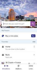
지도/내비게이션
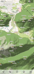
Trekarta - offline outdoor map
Trekarta is designed for hiking geocaching offroading cycling boating and all other outdoor activities It uses offline maps so you do not need to have internet connection You can easily import places and tracks from GPX and KML data formats or create places in application and share them to others It lets you write the track of your journey even in background so you will never get lost and be able later see where you39ve been
Offline maps
Trekarta uses OpenStreetMap based vector maps that are lightweight offline and are constantly enhanced by contributors Maps contain detailed topological data with elevation contours Some map elements can be filtered out for cleaner look Trekarta has builtin hillshades support You can add custom maps in sqlite or mbtiles format to cover your area of interest Custom maps will be shaded as well Such maps can be created by yourself with SASPlanet application from mostly any online source or converted with MapTiler and other applications from other map formats
Hiking
Special hiking activity mode emphasises paths and tracks on map It visualizes path difficulty and visibility and displays hiking routes It also displays special OSMC symbols that help you identify desired route
Cycling
Cycling activity mode reveals bicycle infrastructure It shows cycling routes and visualizes mountain biking track difficulty and visibility
Skiing and skating
Skiing activity mode displays clean winter map with mostly all skiing activities downhill nordic hiking and touring As a bonus freestyle snowboarding skating and sleighing areas are displayed
Offroad
Unpaved dirt winter and ice roads are specially visualized 4wd only roads have specific marking Fords are displayed on all roads even primary
Places
Places can be easily imported from GPX and KML files or can be created within application You can navigate to places and share them with others
Tracks
Trekarta is designed to record tracks of your journey Simply press a button when you start and press it once more when you finish You can quit the application if you do not need to look at the map the track will be recorded in the background
Plugins
Trekarta functionality can be extended by plugins Currently the following plugins are available
Location sharing
Dropbox sync
More info
More information can be found at
https//githubcom/andreynovikov/trekarta/
Questions can be asked at
https//githubcom/andreynovikov/trekarta/discussions
- 평점
- 평점 0
- 무료

42
자세히보기
![]()


공지사항
- 소프트쉐어 신규 소프트웨어 추가 안내 2025.01.17
- 소프트쉐어 서비스 이용 가이드 업데이트 안내 2025.01.17
- 소프트쉐어 웹사이트 리뉴얼 안내 2025.01.17