


 다운로드 TOP50
 PC 카테고리
 자유게시판
자유게시판
Mgrs & Utm Map
 다운로드수 153
-
4.9 (0명)
| 분류 | 지도/내비게이션 |
|---|---|
| 버전 | 7.3.5 |
| 연령 | 3세 이상 |
| 업데이트 | 2017. 7. 30. |
| 금주 다운수 | 0 |
| 누적 다운수 | 153 |
| 개발사 | DakikTech |
| 다운로드 | |
|
!소프트웨어 사용범위 위반 시
법적 책임을 질 수 있습니다. |
|


상세정보
This application is GPS and coordinate systems helper especially for military personnel
It is also a complete helper for mountaineering trekking and hiking cross running scouting hunting fishing geocaching offroad navigation and all other outdoor activities and sports
With satellite navigation systems such as GPS GALILEO and GLONASS GNSS supported by your device and your sensors you can see your most accurate position on different map layers
Features
Easy and Faster
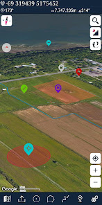
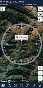
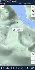
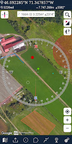
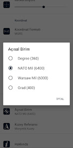
Compass
gt Compass on map on the map that shows your direction
gt Compass only shows physical directions
gt Angular units for compass degrees NATO mil Soviet Mil Grad
Follow Mode
gt The center of the map follows your location while on the move
You can add and removing markers
Distance measure You can add custom route and calculate total distance
Area measureYou can select an area on the map and calculate the area in square meters
You can see the altitude of your location
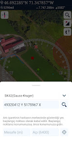
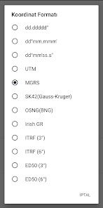
You can find the location according to Degree/Minute/Second MGRS UTM or Latitude/Longitude formats
Location Coordinate format options
gt MGRS / US National Grid USNG WGS84/NAD83
gt DM39Squot WGS84
gt Latitude/Longitude WGS84
gt UTM WGS84/NAD83
gt SK42Gauss Kruger
Map type options RoadTerrainSatelliteNight ModeHybrid
You can share location coordinate
Distance unit options meter and feet
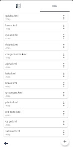
KML viewer Export and import KML layers
GPS track recorder
리뷰
- 소프트쉐어 신규 소프트웨어 추가 안내 2025.01.17
- 소프트쉐어 서비스 이용 가이드 업데이트 안내 2025.01.17
- 소프트쉐어 웹사이트 리뉴얼 안내 2025.01.17


