


 다운로드 TOP50
 PC 카테고리
 자유게시판
자유게시판
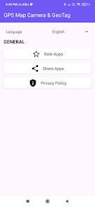
GPS Camera : GEO TAG Map
 다운로드수 628
-
0 (0명)


| 분류 | 사진 |
|---|---|
| 버전 | 1.2.3 |
| 연령 | 3세 이상 |
| 업데이트 | 2024. 8. 14. |
| 금주 다운수 | 0 |
| 누적 다운수 | 628 |
| 개발사 | Dev Library |
| 다운로드 | |
|
!소프트웨어 사용범위 위반 시
법적 책임을 질 수 있습니다. |
|


상세정보
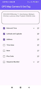
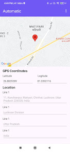
GPS Camera GEO TAG Map is a powerful and versatile tool designed to capture photos while automatically attaching the location coordinates to the images Perfect for travelers surveyors and professionals who need to document places with accuracy the app integrates your devices GPS capabilities to embed essential geolocation metadata including latitude longitude altitude and timestamp
Key features include
Realtime GPS data tagging for each photo
Customizable watermarks for location details date and time
Interactive maps to view photo locations directly
Options to add custom notes or location descriptions
Easy sharing of geotagged photos for seamless collaboration
Ideal for outdoor enthusiasts real estate professionals and field workers GPS Camera GEO TAG Map ensures that your photos are not only visually appealing but also geographically informative
리뷰
- 소프트쉐어 신규 소프트웨어 추가 안내 2025.01.17
- 소프트쉐어 서비스 이용 가이드 업데이트 안내 2025.01.17
- 소프트쉐어 웹사이트 리뉴얼 안내 2025.01.17


