


 다운로드 TOP50
 PC 카테고리
 자유게시판
자유게시판
ShipIntel by Maritime Optima
 다운로드수 5,773
-
0 (0명)


| 분류 | 생산성 |
|---|---|
| 버전 | 6.0.0 |
| 연령 | 3세 이상 |
| 업데이트 | 2022. 1. 25. |
| 금주 다운수 | 0 |
| 누적 다운수 | 5,773 |
| 개발사 | Maritime Optima AS |
| 다운로드 | |
|
!소프트웨어 사용범위 위반 시
법적 책임을 질 수 있습니다. |
|


상세정보
ShipIntel Better decisions today with tomorrow39s maritime solution
ShipIntel is for any maritime company focusing on team efficiency and maximizing profit
A perfect complementary team software to your existing solutions where you can tailormake your software by selecting the modules you want
Whether you are a broker a chartering manager or working for some other company involved with the maritime industry you should run your organization more efficiently We aim to make internal communication and data exchange between partners more efficient so you can get more work done whether working for a large enterprise or a small business
ShipIntel is available crossplatform Log in to ShipIntel from your mobile or web Your data and work are always in sync across platforms
Why give ShipIntel a try
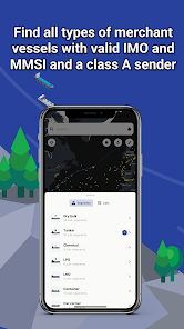
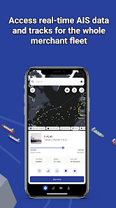
LIVE AIS Data
Find where all types of vessels are in almost realtime AIS positions the vessels39 last port of call and the next port they are heading to with ETA present speed and estimated laden/ballast condition All the vessels have a valid IMO MMSI and use a class A AIS sender The vessels are divided into types/and sizes segments amp subsegments
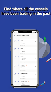
Historical AIS data
Find where all the vessels have been trading in the past
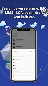
Search for vessels and ports
Search and find vessels by name IMO MMSI or expand your search using LOA beam draft year built etc Search and find ports by name country and cargo type
Vessel and port lists
Create unlimited numbers of fleet lists or lists of ports and add them as layers to your map
Be notified
Be notified when vessels set a destination arrive in a port or at anchorages pass a line or arrive or depart from a region
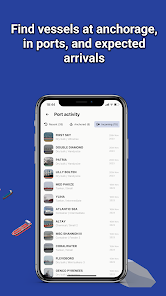
You will also find vessels in ports recent departed and waiting at anchorages listed with name segment and arrival time You will find tides bunker grades prices and availability in each port Vessels presently in ports at anchor and vessels just departed
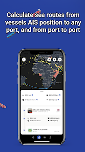
A sea route distance calculator
Create sea route from any vessel39s present AIS position to any port or multiple ports Get the bunker consumption and distance in nautical miles from the vessel39s AIS position to any port or a combination of ports Find the ETA days at sea bunker ports along the route and estimated bunker consumption You can also route between ports
Add notes photos and documents directly attached to a vessel or port or a list of vessels or ports
Map information layers
Sea Ice Piracy and Marine weather are updated every 24 hours
War zones ECA/SECA Economical Zone Load Lines INL and Polar Codes and wind farms
Click on the layers for information on constraints
Choose between map styles and satellite
A crossplatform software Always in sync so you always have the latest update in your pocket
A dedicated and free support chat operated by people with shipping experience is integrated to assist you anytime
Please stop by and learn more on our web page https//maritimeoptimacom/shipintel
리뷰
- 소프트쉐어 신규 소프트웨어 추가 안내 2025.01.17
- 소프트쉐어 서비스 이용 가이드 업데이트 안내 2025.01.17
- 소프트쉐어 웹사이트 리뉴얼 안내 2025.01.17


